

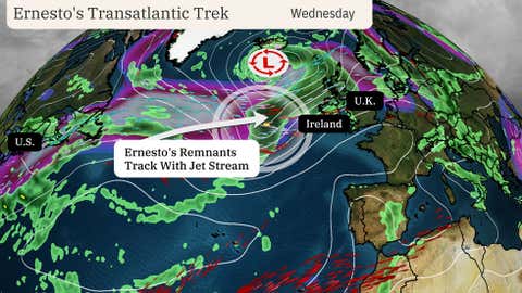
Hurricane Ernesto’s remnants will make a transatlantic journey while merging with a frontal system through midweek, eventually helping to enhance rain and wind in Ireland and the United Kingdom.
Here’s how a former hurricane can reach Europe. Similar to a transatlantic flight, Ernesto will get whisked eastward by the jet stream, which is a narrow ribbon of stronger winds in the upper levels of the atmosphere.
As that happens, the remnant energy and moisture from Ernesto will get pulled into a separate low-pressure system located to its north, as illustrated in the map below. That means Ireland and the United Kingdom (especially north and west areas) will see rain and gusty winds later Wednesday into Thursday, with Ernesto’s leftover moisture and energy being partly to blame.
(15-min details: For even more granular weather data tracking in your area, view your 15-minute details forecast in our Premium Pro experience.)

The circle shows the position of Ernesto’s remnants on Wednesday as it tracks eastward with the jet stream (narrow, white, pink and purple band of contours).
This happens nearly every hurricane season. About two storms of tropical origin impact Europe each year, according to recent research. Northern parts of the continent are more likely to be impacted than southern areas.
Impacts from former hurricanes can vary from minor to major in Europe. The impact from Ernesto’s remnants leans more toward the minor end of this spectrum when it comes to former tropical storms and hurricanes making this journey.
One of the most potent recent examples happened with former Hurricane Ophelia in October 2017.
While Ophelia lost its tropical characteristics before reaching Ireland, it produced wind gusts to 119 mph in Ireland and 86 mph in the U.K. Three were killed in Ireland in what was considered its worst storm in 50 years.
It’s not just Ireland and the United Kingdom – other parts of western Europe have had multiple encounters in recent years.
Subtropical Storm Alpha made landfall in Portugal in 2020, becoming the first known subtropical or tropical cyclone to do so in that country. Former Hurricane Leslie brought wind gusts over 100 mph to Portugal and flooding to France in 2018.
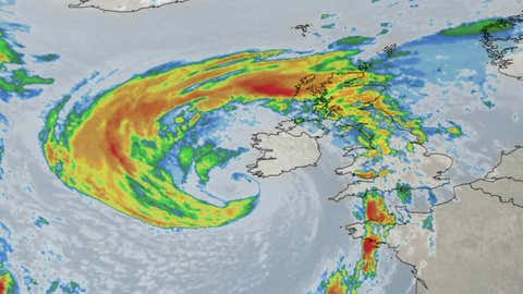
Satellite view of former Hurricane Ophelia impacting Ireland and the United Kingdom on Oct. 16, 2017.
(192-hours: Further beef up your forecast with our detailed, hour-by-hour breakdown for the next 8 days – only available on our Premium Pro experience.)
Chris Dolce has been a senior meteorologist with weather.com for over 10 years after beginning his career with The Weather Channel in the early 2000s.
Source link : https://weather.com/storms/hurricane/news/2024-08-19-hurricane-ernesto-remnants-rain-ireland-united-kingdom
Author :
Publish date : 2024-08-19 07:00:00
Copyright for syndicated content belongs to the linked Source.