

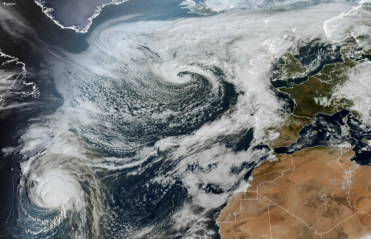
North Atlantic hurricane season 2024 is particularly busy with tropical systems this month, with multiple systems ongoing. One system caught our attention as it turned towards Europe—a major hurricane Kirk. It is forecast to accelerate across the North Atlantic and become an intense post-tropical storm, impacting France, the northwestern tip of Spain, and the UK.
After Monday, the system will accelerate across the North Atlantic and head for Europe’s impact. A gradual transition into an extratropical storm is expected Monday night when hurricane Kirk will be moving eastward to the north of the Azores.
Kirk will continue as an intense post-tropical storm after Monday and reach NW Spain and France by Wednesday and Thursday.
Given the system’s significant tropical origin, its impact could be severe for France and even further inland across Benelux and Germany Wednesday night.
Currently, Kirk is producing ocean swells that are propagating far away from the hurricane. These large swells will likely increase the risk of dangerous surf and rip currents across the Leeward Islands, Bermuda, and the Greater Antilles beginning, much of the U.S. East Coast, Atlantic Canada, and the Bahamas by Sunday, and the Azores by Monday.
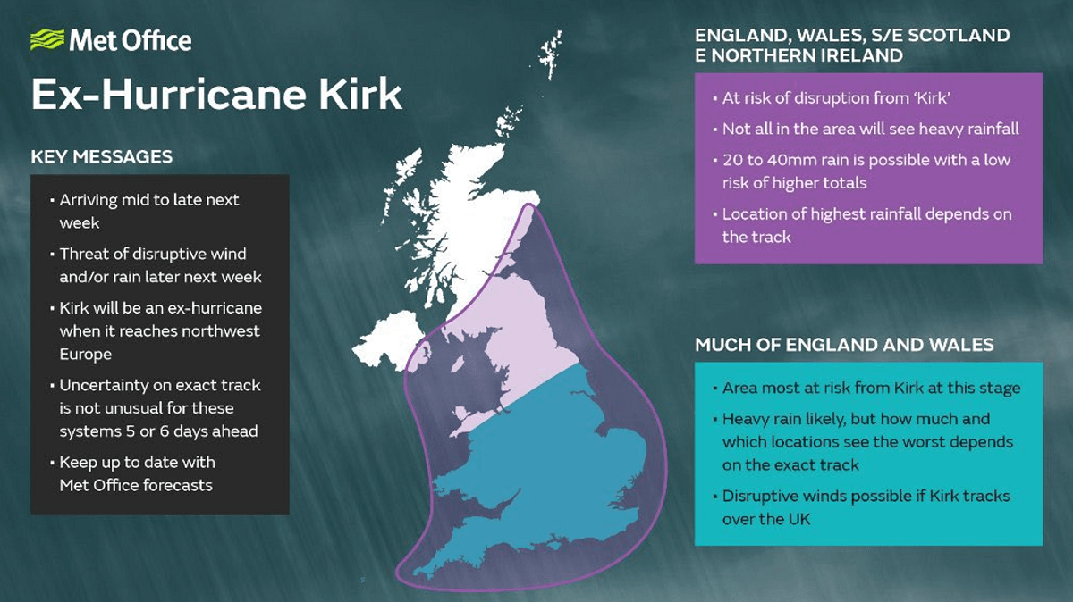
MetOffice has posted some key messages regarding the potential impacts of ex-hurricane Kirk on the UK through mid-week.

Hurricane Kirk moves across the North Atlantic, soon turning toward Europe
During its peak last Thursday, hurricane Kirk had maximum sustained winds of 145 mph—the strongest hurricane this late in the calendar year since Hurricane Iota in 2020. Kirk is the third Category 4-5 Atlantic hurricane this year (the other two were Beryl and Helene).
Reaching such intensity at ~47°N, Kirk shattered the record for the farthest east, an Atlantic Category 4-5 hurricane in November. The old record was Hurricane Sam in 2021 on 2 October at ~60°W.
A continuing gradual weakening is forecast until Monday, then hurricane Kirk transitions into an extratropical cyclone and turns towards the impact on Europe’s land.

Kirk is a large tropical cyclone with a central pressure of around 960 mbar and a maximum sustained wind speed of 110 mph. It maintains a solid Category 3 major strength. Hurricane-force winds extend outward up to 55 miles (90 km) from the center, and tropical-storm-force winds extend outward to 180 miles (300 km).
Wind shear increased over Kirk Saturday afternoon, but the inner core has remained intact. However, the environment will become more hostile as wind shear increases, with drier mid-level air and cooler sea surface temperatures.

Therefore, steady weakening is forecast through early next week. The system should lose tropical characteristics and transition to a strong extratropical cyclone around late Monday or early Tuesday.
Kirk has a tight inner core, with deep convection wrapping around the center. As shear increases over the system, the eye becomes more cloud-filled.
Heavy rainfall associated with Kirk will mostly miss the Azores on Monday. Still, rainfall amounts should increase along the post-tropical stage as the system travels towards western Europe on Wednesday.

Even though Kirk is forecast to become a post-tropical storm, its impact will likely remain severe as the system reaches the northwestern tip of Spain and coastal France on Wednesday.
Some models also suggest further inland significant impact across Benelux and Germany is possible late Wednesday into Thursday.
Atlantic hurricane season 2024
During an average tropical year, the Atlantic hurricane season produces up to 14 named tropical storms. On average, seven typically become hurricanes. Three of those reach the major strength (hurricane of a Category 3 or greater).
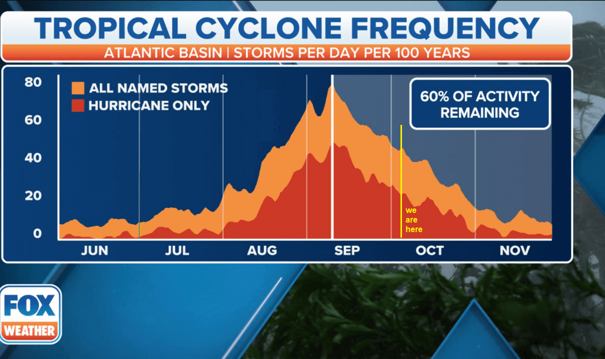
A typical Atlantic hurricane season has two peaks. The first period of increased activity occurs from early through mid-September, while the second boost typically happens through mid-October. Statistically, the general increase in activity across the tropical Atlantic typically begins in the trough early/mid-August.

So far this year, there have been 13 tropical storms and 9 hurricanes, three of which were major hurricanes: Category 5 Beryl, Helene, and now Hurricane Kirk. Beryl devastated the Windward Islands in early July, and Helene recently brought historic floods into North Carolina and a record-breaking storm surge to Florida.
The hurricane season has significantly ramped up in late September.
The seasonal forecasts from the Colorado State University (CSU), led by Dr. Phil Klotzbach, hinted at 23 named tropical systems, with eleven hurricanes and five major storms forecast for hurricane season 2024. That’s well above the 30-year average. Based on the long-term average, a hurricane season typically brings 14 named storms, seven hurricanes where three reach a major intensity (Category 3 or greater).
The most recent analysis from Dr. Klotzbach reveals that the 2024 season is now running higher than expected, with some statistical points even above the long-term average through October 5th.
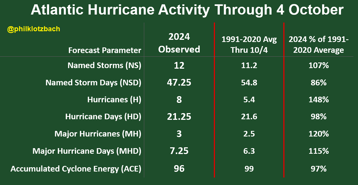

The ongoing hurricanes Kirk and Leslie and the upcoming major storm Milton in the Gulf of Mexico will further push these statistics, especially the hurricane days, major hurricane days, and the Accumulated Cyclone Energy (ACE). ACE is a metric used to compare the overall activity of tropical cyclones—the stronger and longer the storm lasts, the higher the ACE accumulates.
Note that hurricane development is a particular formation in the tropical region. It is susceptible to atmospheric conditions at a given time. The tropical waves coming off Western Africa strongly influence the state of the atmosphere, thus allowing tropical storms or hurricanes to develop and head west into the open North Atlantic.
These systems usually require a hot sea temperature (26 °C or above), very high moisture, and low vertical wind shear through the atmosphere. The tropical wave helps develop a surface low-pressure system.
When these ingredients come together, a tropical cyclone could quickly become a hurricane or even a violent, major hurricane of a greater than Category 3 strength. This happens when all the required conditions are near perfect.
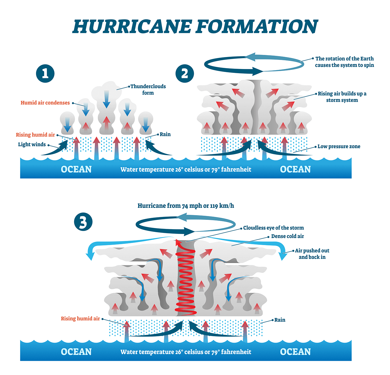

Unlike the mid-latitudes, the tropical region has no warm or cold fronts. Weather activity generally combines showers and thunderstorms with larger-scale pressure and wind variability. Most tropical variability is driven by invisible wave-like features in the atmosphere worldwide.
The two most essential waves are the MJO and Kelvin waves. These two are the second and third most needed ingredients after the warmth of the oceanic waters, respectively.
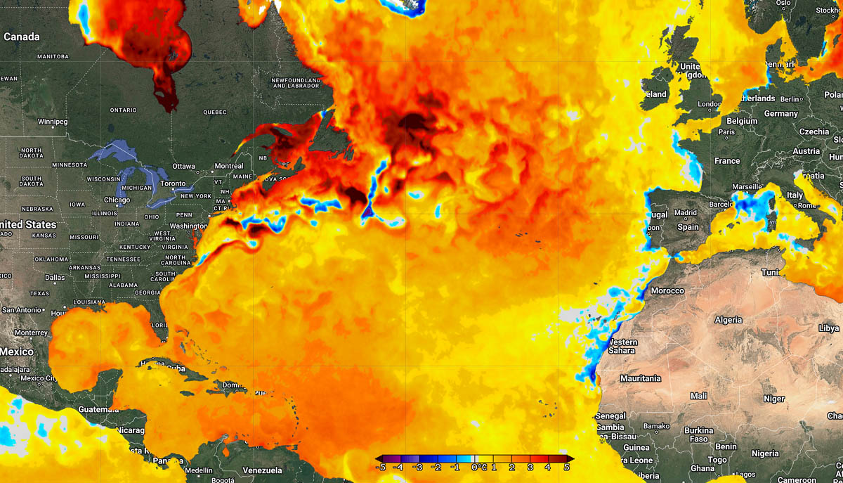
Much warmer-than-average temperature continues over the North Atlantic Basin
The so-called marine heat waves are becoming more frequent and intense in recent years. This year, they are more persistent and spread over large areas, aligned with global overheating climate and seas. It is hard work to find near-normal or colder spots of the Atlantic this year.
Sea temperatures across the North Atlantic, especially the Caribbean and Gulf of Mexico, are extremely hot, still 30-32 °C across a large part of the western Atlantic. This is a great concern for potential storms that may track into this source of high ocean heat during the peak of the hurricane season, which is why we are seeing explosive storm development this year.
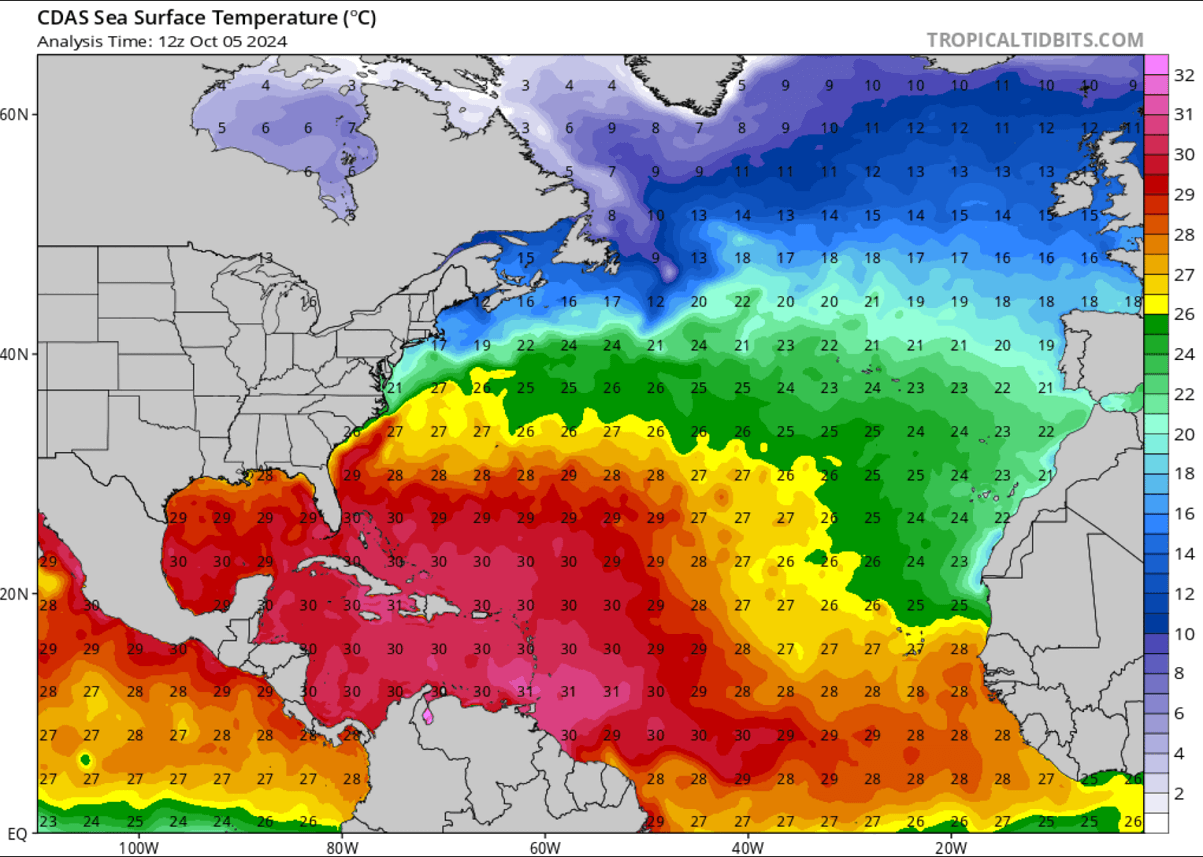

The tropical central and western Atlantic regions remain above normal this early October. This correlates well with what is typically seen during an active Atlantic hurricane season. The near-term SST anomaly forecast also hints that temperatures will remain very high throughout the fall months.
The North Atlantic has water temperatures well above the average, including in the portion where Hurricane Kirk will travel in the coming days. Seas around the Azores are particularly warm, around 3-4 °C above normal.

During the summer months, we closely monitor Western Africa’s weather conditions. This is where the tropical waves emerge into the eastern Atlantic Ocean. Data shows that nearly 85% of these waves lead to organized deep convection over the warmer oceans and become tropical depressions or storms.
While during August and September, the system generally travels westward into the Caribbean and towards the US mainland, it tends to have more northerly tracks later in the season. This is why it sometimes heads towards Europe during the fall months.
Hurricane Kirk turns towards Europe on Tuesday, becomes an intense extratropical cyclone
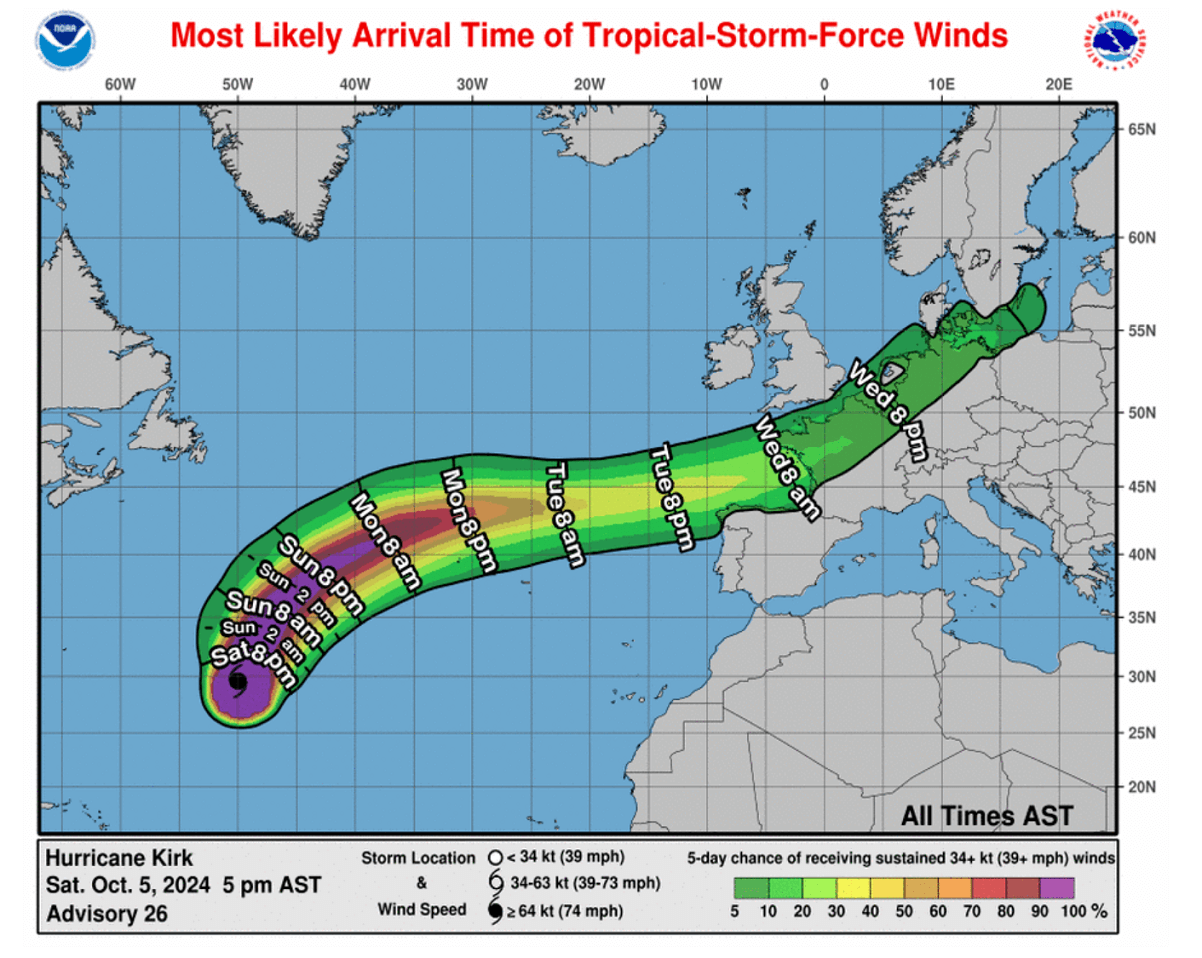
The National Hurricane Center forecasts Kirk to remain a Category 2 hurricane through Monday afternoon, gradually weakening while transitioning into an extratropical storm early Tuesday. After Monday, the system will also accelerate toward the open North Atlantic.
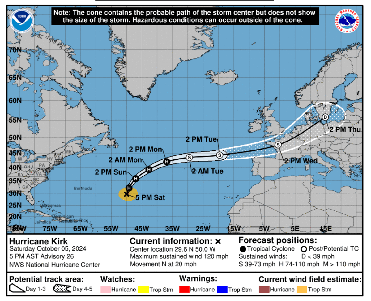

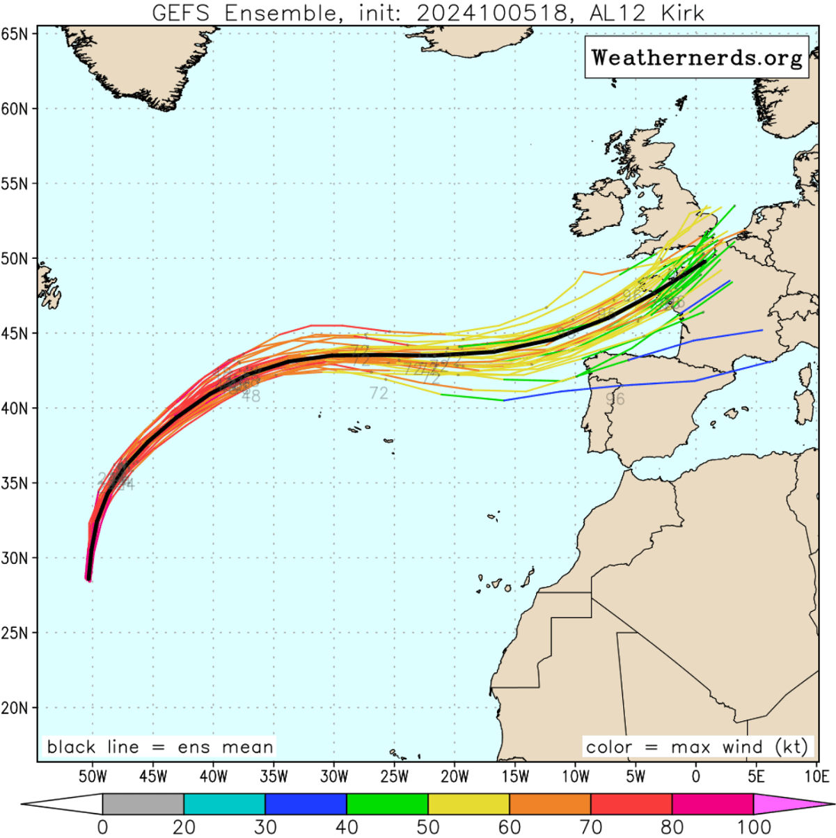
Kirk continues to move northward and increase forward speed with an estimated motion of (020/22 kt) between a trough over the west-central Atlantic and a subtropical ridge in the east Atlantic. The model track guidance remains tightly clustered, although there has been a slight shift southward as the system transitions and becomes post-tropical.
The NHC forecast track shows the center of Kirk passing just to the north of the Azores on Monday as an extratropical cyclone, then moving across the northeastern Atlantic and western Europe by the middle of this week.

Given the supportive high ocean temperatures along Kirk’s track, the system will remain intense over the Atlantic and likely grow larger through Tuesday, a typical occurrence after a transition into an extratropical storm occurs.
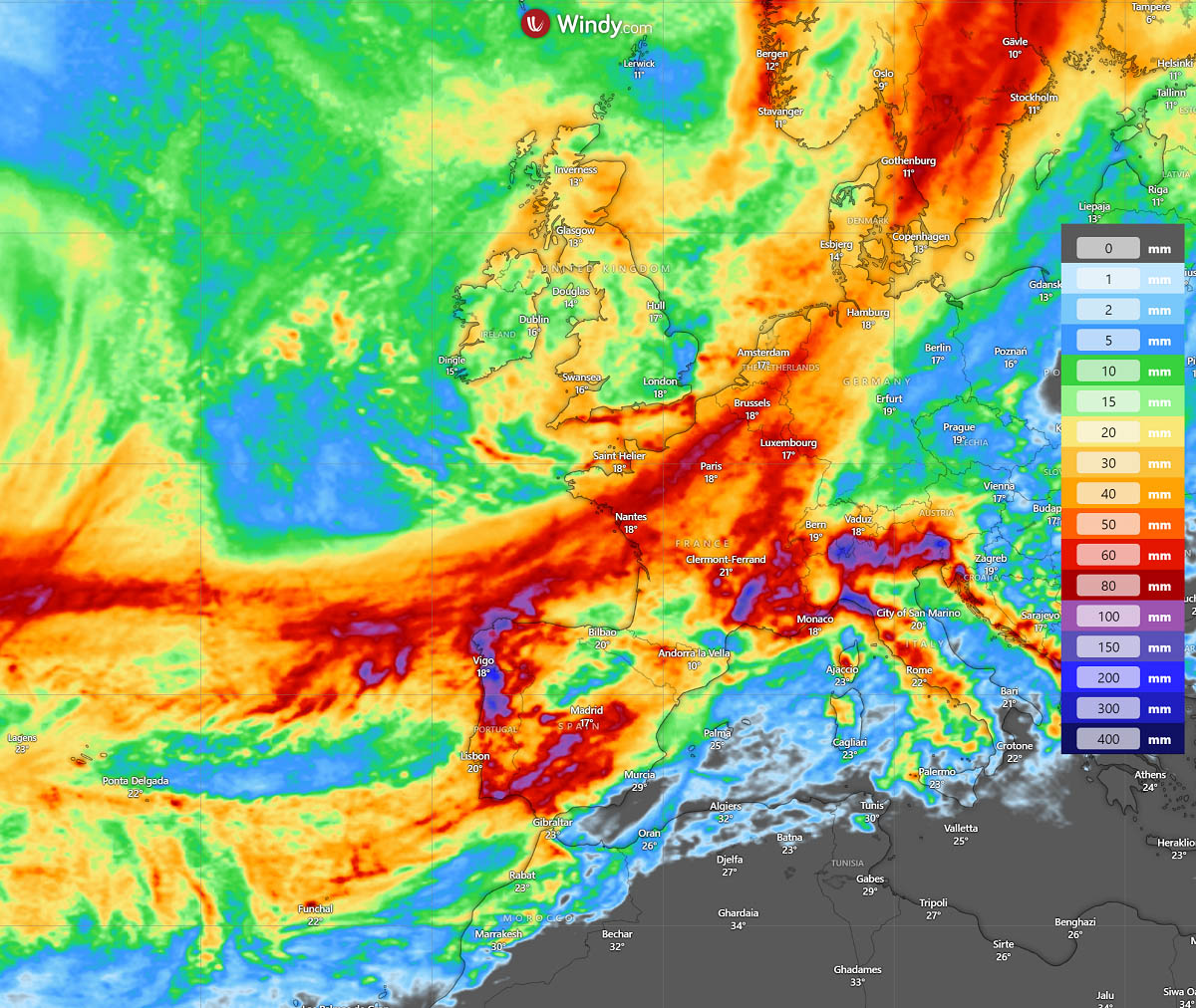
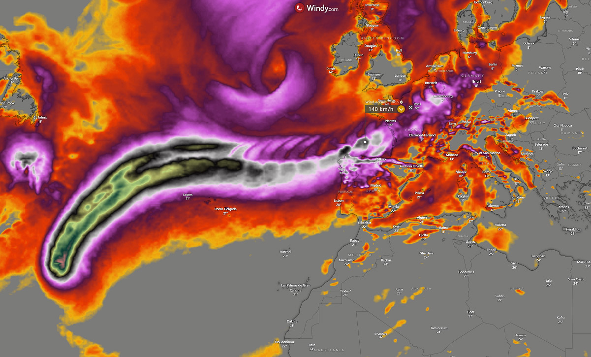
Below is an impressive wind gust accumulation swath map from the ECMWF global weather model over the next six days. It shows that hurricane strength remains around the Azores, and the swath curves towards NW Iberia, France, Benelux, and the UK.

The system then maintains tropical-storm-force strength while crossing the North Atlantic and will reach western Europe by Wednesday.
Although it is relatively hard to forecast how intense the extratropical system will be once it reaches western Europe, the general weather model consensus hints that winds at 70-80 mph and high swell and waves late next week are possible.
High-resolution weather models hint at the significant impact once the storm grazes into the Bay of Biscay and France through Wednesday night. As the center arrives in western France, there is an increasing potential for severe, destructive winds. Wind gusts could be higher than 150 km/h along the coast. Storm surge and coastal flooding could also occur.
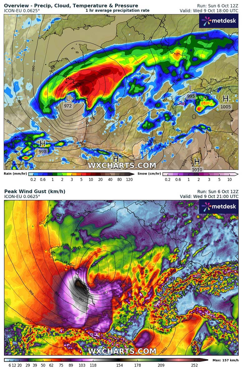

The most likely track will bring ex-hurricane Kirk towards western France late Wednesday. The most significant impact will come from intense winds and rainfall near and to the northeast of the low’s core.
There is potential for windstorms also further inland across central France and western Germany, including the Alpine region, while the low races towards northeast across western Europe Wednesday night.
Below is a video animation of the ex-hurricane Kirk grazing into France from late Wednesday to Thursday morning.
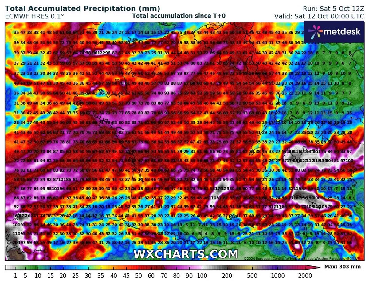
The rainfall amounts across Western Europe will bring a swath of around 70-120 mm of precipitation. The highest amounts will be along the core. However, as discussed above, the exact path is still uncertain.

The most severe impact by winds and rain will be from west-central France to the southern UK, including Benelux.
Although Kirk will not be a hurricane once it reaches Europe, its impact as a potentially significant windstorm will be severe.
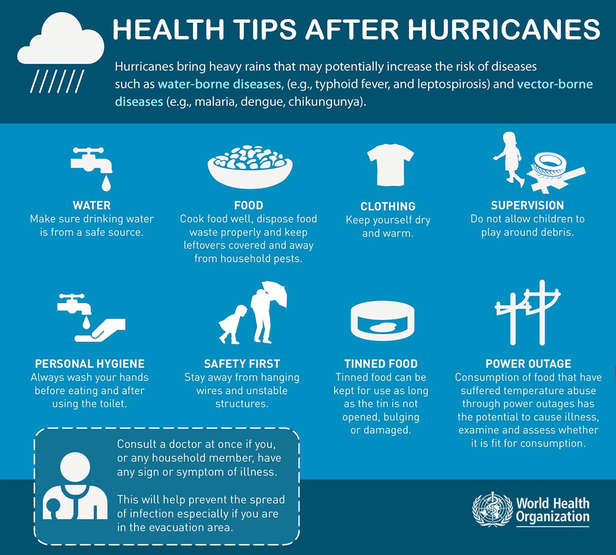
Below is some safety information regarding hurricane season, but effects on coastal areas could be quite similar, especially with European impacts from storms that originate from tropical cyclones.
Safety Preparedness during a Hurricane Season


Have a plan
The official hurricane season in the North Atlantic and the Caribbean starts on June 1st and ends on November 30th. This is when you and your family must be prepared by planning.
Write emergency phone numbers and keep them on the refrigerator or near every phone in your house. It would help if you also programmed them into your cell phone.
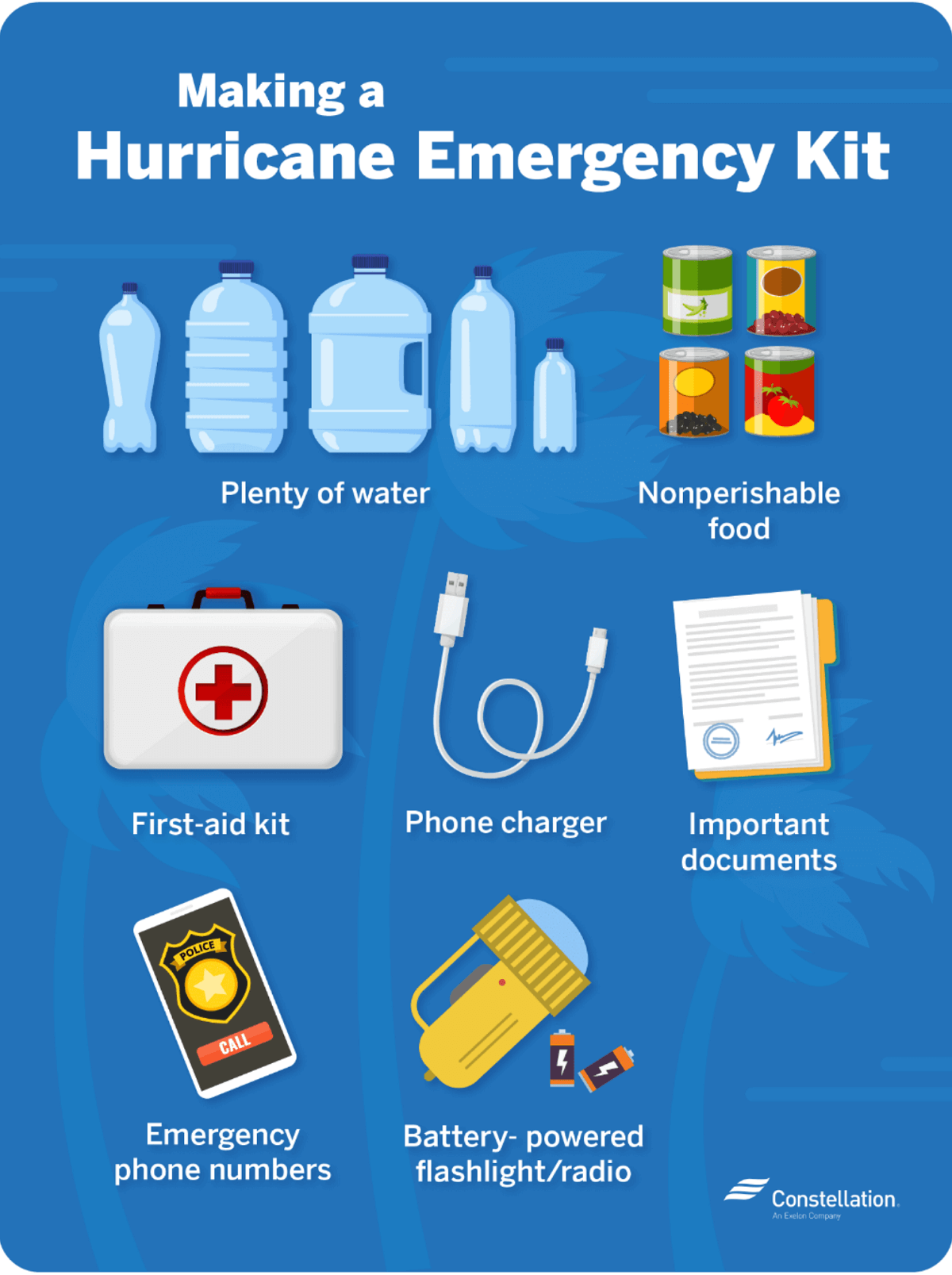
Prepare an emergency supply kit.
Locate the nearest shelter in your area and different routes from your home in an emergency. If shelter locations in your area have yet to be identified, learn how to find them before the event of a storm.
Pet owners: Take care of your pets at pre-identify shelters, a pet-friendly hotel, or an out-of-town friend or relative where you can take your pets in case of an evacuation. Local animal shelters can offer advice on what to do with your pets if you are asked to evacuate your home during a hurricane.
Learn the difference between a hurricane “Watch” and “Warning”
When you listen to the National Weather Service alerts on TV or radio or check for them online, there are two kinds of alerts:
A hurricane watch means hurricane conditions (sustained winds of 74 miles per hour [mph] or higher) are possible in a stated area. The National Hurricane Center (NHC) will announce hurricane watches 48 hours before they expect tropical storm-force winds (sustained winds of 39 to 73 mph) to start.
A hurricane warning is a more severe threat. This means that hurricane-force winds are expected in a stated area. NHC issued these warnings 36 hours before tropical storm-force winds were expected in the area to give people enough time to prepare for the storm.
Check out the National Weather Service’s Hurricane Center for more information about hurricane watches and warnings. If you hear a hurricane watch or warning in your area, you can take steps to get ready.
Get your car ready to leave home if needed
Make sure your car is ready before the tropical storm or hurricane hits.
Fill the gas in your car’s tank.
Move cars and trucks into your garage or under cover.
Always keep an emergency kit in your car.

If you don’t own a car, consider making plans with friends and family or call authorities to get a ride if you need to evacuate.
Get your family and pets ready
Go over your emergency plan with your family; understand everything.
Keep checking for weather updates about the storm. You can watch TV, listen to the radio, or check the NHC website online.
Call the hospital, public health department, or the police about special needs. If you or a loved one is older or disabled and won’t be able to leave quickly, get their advice on what to do.
Put pets and farm animals in a safe place.
Get your home ready
Clear your yard to ensure nothing could blow around during the storm and damage your home. Move bikes, lawn furniture, grills, propane tanks, and building materials inside or under the shelter.
Cover up house windows and doors. Use storm shutters or nail pieces of plywood to the outside window frames to protect your windows. This can help keep you safe from flying debris and pieces of shattered glass.
Be ready to turn off your power if you see flooding, downed power lines, or you have to leave your home. Switch your power off completely.
If you lose your water supply during the storm, fill clean containers with drinking water. You can also fill your sinks and bathtubs with water for washing.
Double-check your carbon monoxide (CO) detector’s battery to prevent CO poisoning.
Be ready to evacuate or stay at home
During a hurricane warning, always listen to authorities regarding whether you should evacuate or stay home.


If a hurricane is coming, you may hear an order from authorities to evacuate (leave your home). Never ignore an order to evacuate. Sturdy, well-built houses may not hold up against a hurricane’s power. Staying home to protect your property is not worth risking your family’s health and safety.
There are occasions when you may hear an order to stay at home. If driving conditions are too dangerous, staying home might be safer than leaving. Respect the authorities’ decisions.
If you need to evacuate:
Grab your emergency supply kit and only take what you need (cell phone, chargers, medicines, identification like a passport or license, and cash).
Unplug your appliances. If you have enough time, turn off the gas, electricity, and water.
Follow the roads emergency workers recommend, even if dense traffic is expected. Other routes might be blocked or already flooded. Never drive through flooded areas, as cars and other vehicles can be swept away or may stall in just 6 inches of moving water.
Contact your local emergency management office and ask if they offer accommodations for owners and pets.

If you need to stay home:
Keep your emergency supply kit anywhere where you can easily access it anytime.
Follow weather updates online from NHC, and listen to the radio or TV for updates on the hurricane.
Stay inside. Even if it looks calm, don’t go outside. Wait until you hear an official message that the hurricane is over. Sometimes, the weather gets calm in the middle of a storm but then quickly worsens again.
Stay away from windows. You could get hurt by flying debris, such as pieces of broken glass or other objects picked up by winds around the neighborhood during the storm. Stay in a room without windows or go inside a closet.
Be ready to leave home. If emergency authorities order you to leave or your home is severely damaged, you may need to go to a shelter or a neighbor’s house.
Our expert forecaster team will actively follow the tropical region activity worldwide, including Atlantic Basin systems and tropical cyclones likely to affect the United States, the Caribbean, and Europe again in the following months.
Stay tuned for further follow-up posts, in-depth forecast discussions, and nowcasting during the coming weeks and throughout the upcoming Atlantic hurricane season 2023 peak months. We will prepare you.
Windy, NHC, Colorado State University, Tropical Tidbits, and WHO provided images used in this article.
See also: Storm Helene in Florida
Source link : https://www.severe-weather.eu/global-weather/hurricane-season-2024-forecast-major-storm-kirk-north-atlantic-uk-france-mk/
Author :
Publish date : 2024-10-06 19:20:10
Copyright for syndicated content belongs to the linked Source.