

We are live tracking the Storm Ashley – the first named North Atlantic storm of the season.
Our official forecast of the Storm Ashley can be found below:
An explosive development of storm Ashley will blast into Ireland and Scotland on Sunday
Note: This post is regularly updated as the system evolution develops. The most recent update is always at the top of the article. Stay tuned.
Peak gust up to 140 km/h in Ireland, 180 km/h in Scotland
Update: Oct 20th, 19:00 UTC
Peak wind gusts in Scotland:
177 km/h – Bealach Na Ba No2
169 km/h – Aonach Mor
166 km/h – Cairngorm
154 km/h – Cairnwell
127 km/h – Aberdaron
121 km/h – Capel Curig
113 km/h – Tiree
112 km/h – West Freugh
110 km/h – South Uist Range
Peak wind gusts in Ireland:
137 km/h – Mace Head
133 km/h – Belmullet
119 km/h – Connaught Airport
115 km/h – Claremorris
112 km/h – Malin Head
108 km/h – Roches Point
108 km/h – Valentia Observatory
108 km/h – Finner
104 km/h – Sherkin Island
104 km/h – Shannon Airport
101 km/h – Dublin Airport
Peak wind gusts up to 140 km/h in western Ireland and Scotland so far
Update: Oct 20th, 14:00 UTC
The latest wind and wind gusts analysis from Met Eireann and Met Office weather stations indicate that the highest winds have reached 120 to 140 km/h across western Ireland.
Wind gusts up to 140 km/h have already been observed in northwest Scotland, and even higher across the Cairngorms peak, where up to 166 km/h peak gusts were observed until early this afternoon.
Winds are expected to increase further as the core of the Ashley will be traveling across northwestern Scotland and the Outer Hebrides tonight.
The core of Ashley is moving toward western Scotland this afternoon
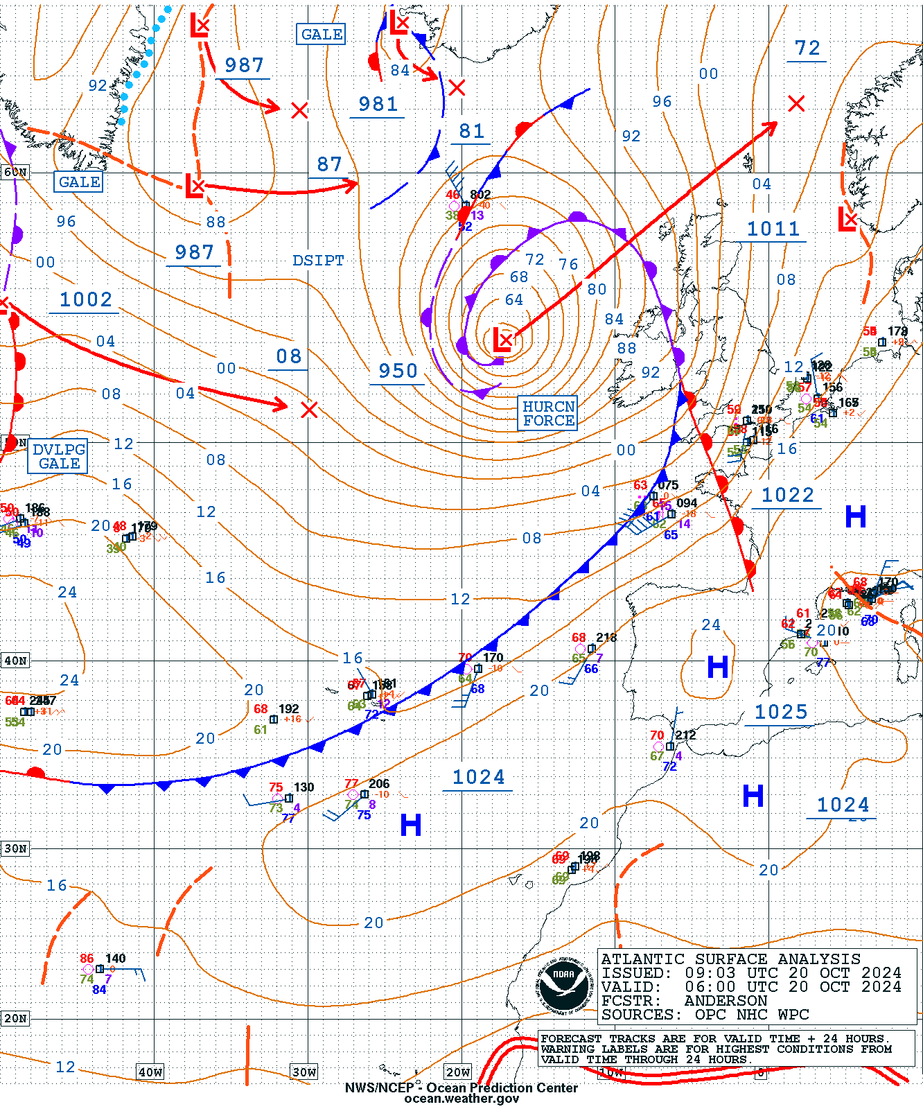
Update: Oct 20th, 13:00 UTC
Here’s the latest surface analysis across the UK and Ireland. We can see a deep core of Ashley, which has no 958 mbar, located northwest of Ireland, gradually moving northeast towards Scotland through Sunday afternoon and evening hours.
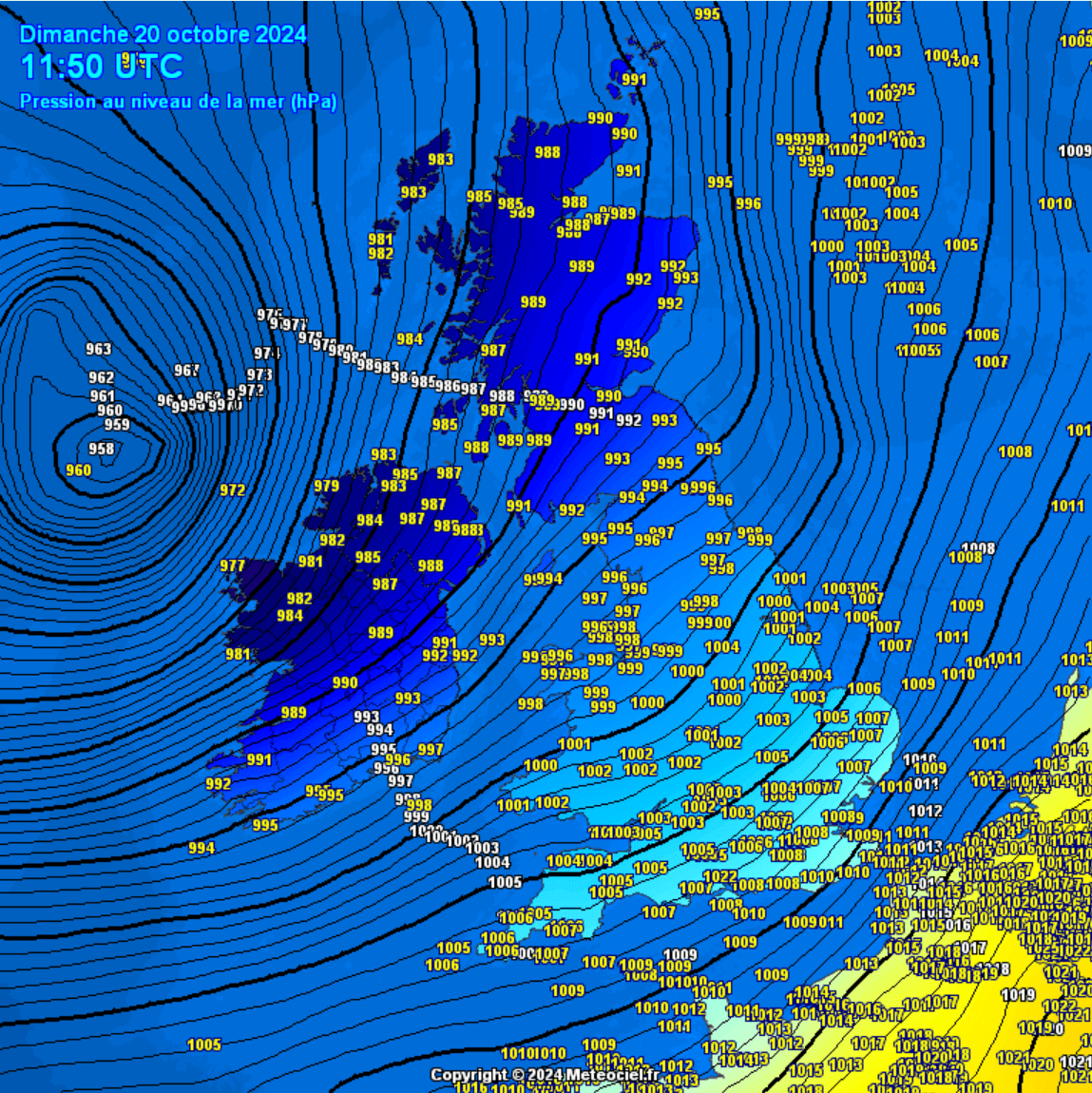

Near the core, we can see a yellow mark “960”; this is the oceanic buoy 62105, which measures meteorological data on the ocean surface. Attached below is the spectacular surface pressure data chart.
The pressure buoy reported at 1 p.m. on Saturday, October 19th, was 1002.5 mbar before the storm Ashley started closing in. Data reveals a steady, occasionally rapidly falling central pressure until it bottomed out at 960.0 mbar at 11 a.m. this morning, Sunday, October 20th.
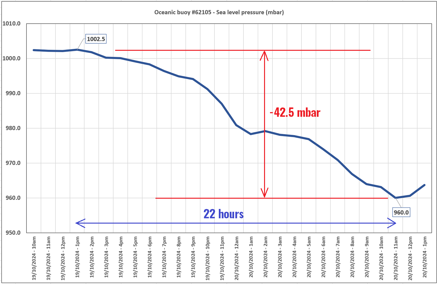

This indicates that the pressure drop at this oceanic buoy has fallen for 42.5 mbar hours in just 22 hours. Remember the bombogenesis criteria of 24 mbar pressure drop in 24 hours? This is nearly double the speed since the average pressure falls were around 1.95 mbar per hour.
However, Storm Ashley’s center did not directly pass the buoy; it was a nearby pass.
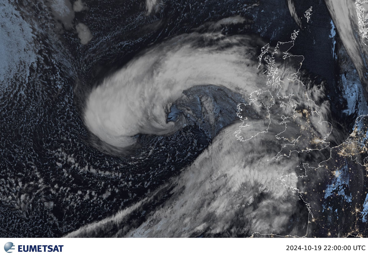
Impressive high-resolution satellite image of Ashley
Update: Oct 20th, 11:00 UTC
Daytime revealed an impressive satellite presentation of storm Ashley’s core late this morning, scanned with a high-resolution VIIRS NASA satellite. One can see the large core of the storm and the typical appearance of cloud patterns, where the most intense winds are present, spreading towards northwestern Ireland, as seen in the image below.
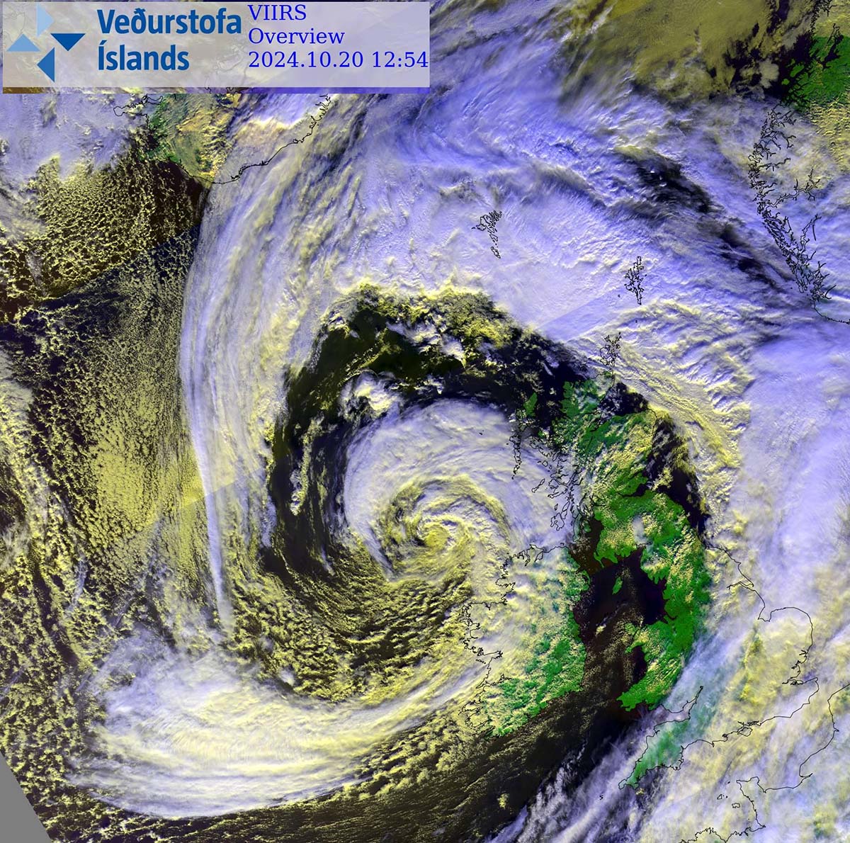

Notice also a narrow corridor of cloudless swath around the core. That is the dry conveyor belt around Ashley’s center. This wrapping belt helps the wind maintain its violent strength as it descends towards the surface.
Morning analysis reveals Ashley’s central pressure at 950 mbar
Update: Oct 20th, 06:15 UTC
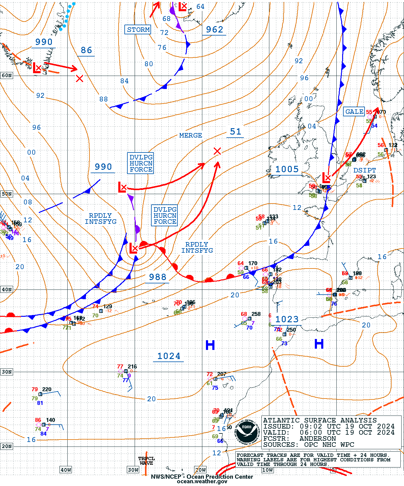
Below is today’s 00 UTC analysis from the Irish meteorological service Met Eireann across Europe and the North Atlantic.
It indicates the warm advection ahead of the main cold front into France and the southern UK, while cold maritime air is spread behind the storm from the north.
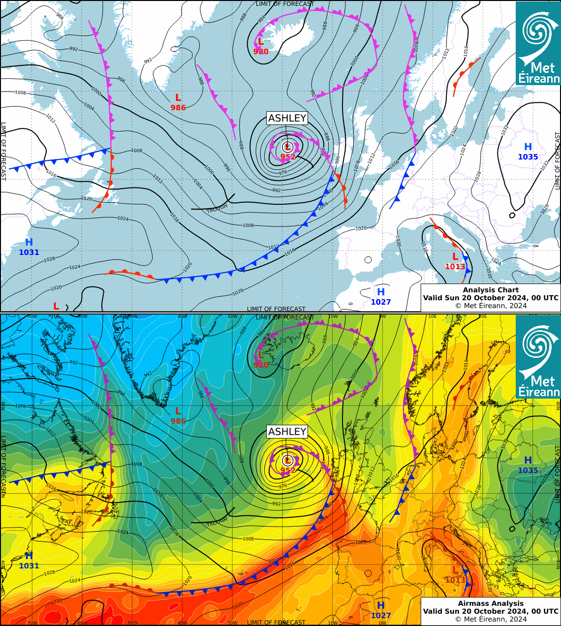

Here’s the latest NOAA NCEP Ocean Prediction Center surface analysis across the North Atlantic this morning, 6 UTC.
Storm Ashley’s central pressure bottomed out at around 950 mbar.

Violent, hurricane-force winds are spread to the south-southeast of the core, where the sting jet had increased the wind field a couple of hours ago. This wind maximum is gradually moving towards western Ireland.
Sting jet wind maximum likely in development
Update: Oct 19th, 23:00 UTC
There is an impressive satellite presentation tonight as storm Ashley is nearing its peak intensity. Below are Water Vapor (WV) and Infrared (IR) Geocolor satellite scans by EUMETSAT.

Notice there’s a potential sting jet wind maximum in development, with an obvious hook-alike appearance on the satellite. It looks just like a scorpion’s tail, which is where this weather phenomenon got its name.
The evaporative cooling process, with strong winds descending towards the surface, creates a clear path through the precipitation. This makes the air much denser within the jet and accelerates the winds’ downward momentum. In other words, violent winds are pushed down with higher force towards the tip of the cloud head when it wraps around the cyclone’s dead center.
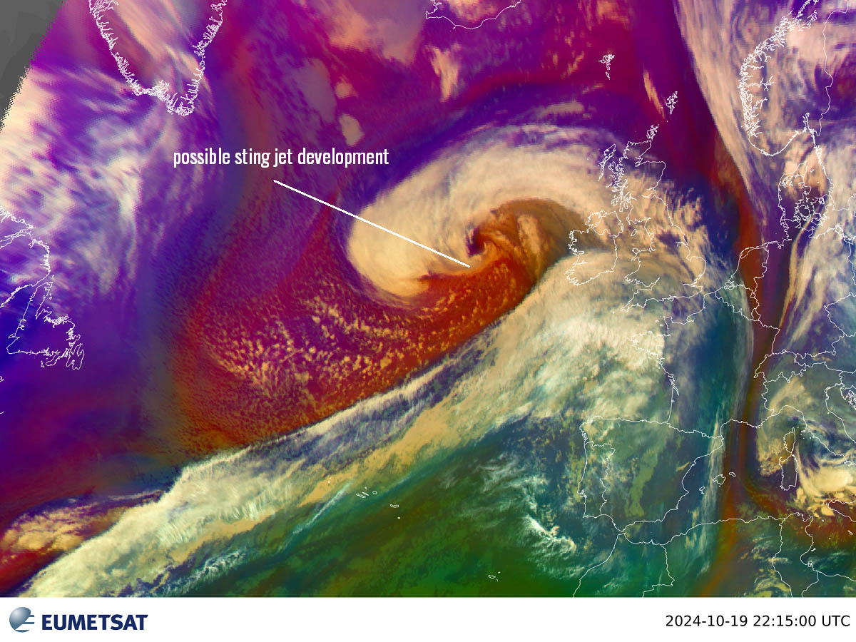

Read more about this extreme weather phenomenon: What is a Sting Jet?
Bombogenesis underway, pressure is down to around 960 mbar at 21 UTC
Update: Oct 19th, 21:00 UTC
This evening, impressive infrared and water vapor satellite imagery shows the storm Ashley still explosively deepening. A sharp, dry conveyor belt wraps around the storm’s core. The wind field is significantly increasing, resulting in high waves spreading towards the western coast of Ireland.
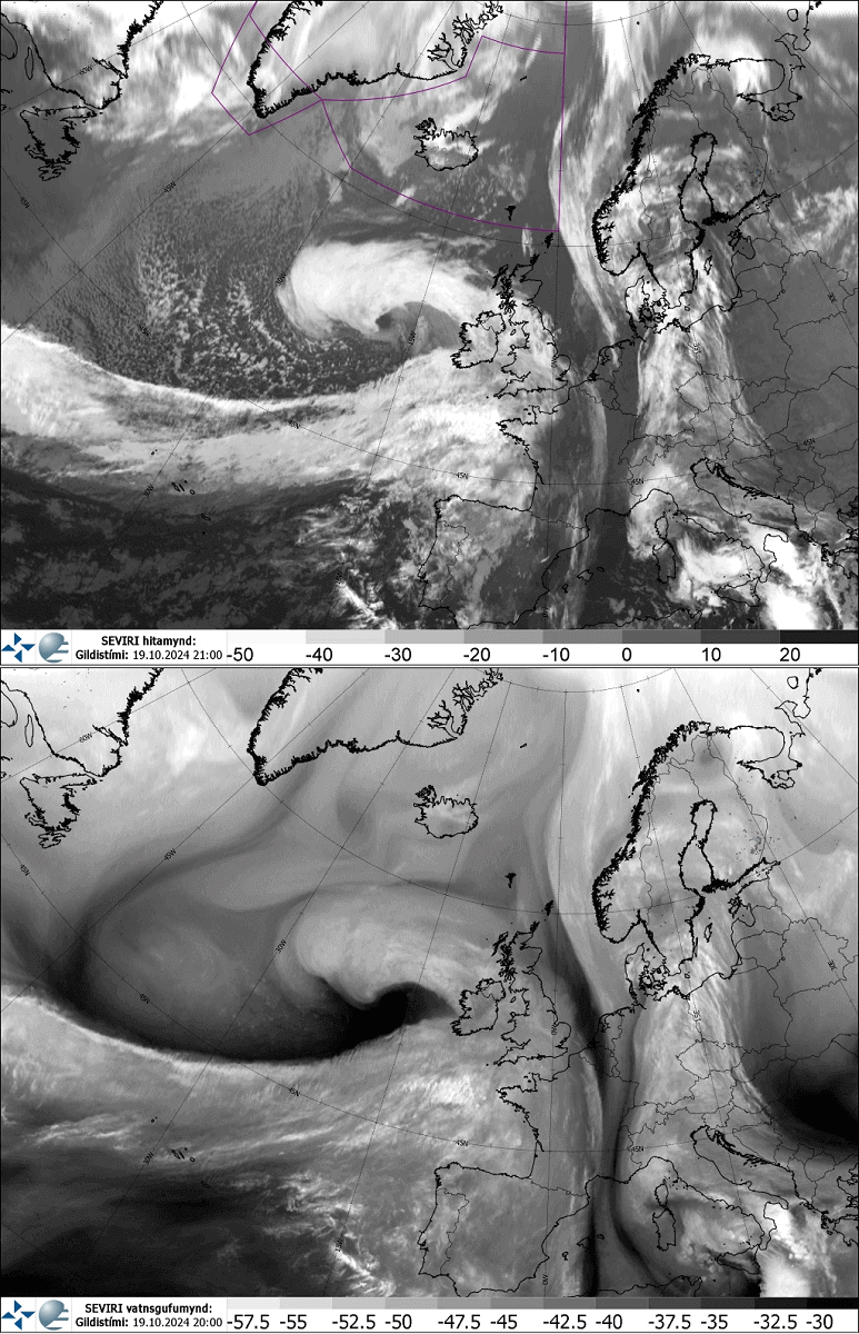

Ashley has two cores close to each other, but weather models suggest they will merge into one intense center overnight before the system peaks.
It is now nearing Ireland, having its central pressure around 960 mbar as of 21 UTC analysis.


Ashley is tracking east-northeast and will pass very close to the north of oceanic buoy 4402729. Data from the buoy reveal an impressive pressure fall today. From 7 UTC to 21 UTC (14 hours), the pressure drop was from 1002 to 969 mbar.
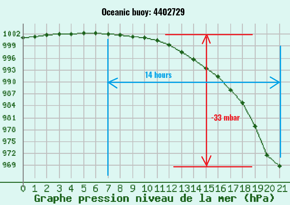

This is a pressure drop of 33 mbar in just 14 hours. So, if this could be normalized to a 24-hour period, its pressure drop would be more than double the bombogenesis criteria threshold of a 24 mbar drop within 24 hours. The rapid intensification is extreme.
Orange / Amber warnings for Ireland, Northern Ireland, and Scotland have been issued
Update: Oct 19th, 18:00 UTC
Met Éireann, the Irish Meteorological Service, has issued orange wind warnings for the western coasts of Ireland for Sunday, October 20th, 2024.
Orange – Wind warning for Clare, Kerry, Donegal, Galway, Leitrim, Mayo, Sligo
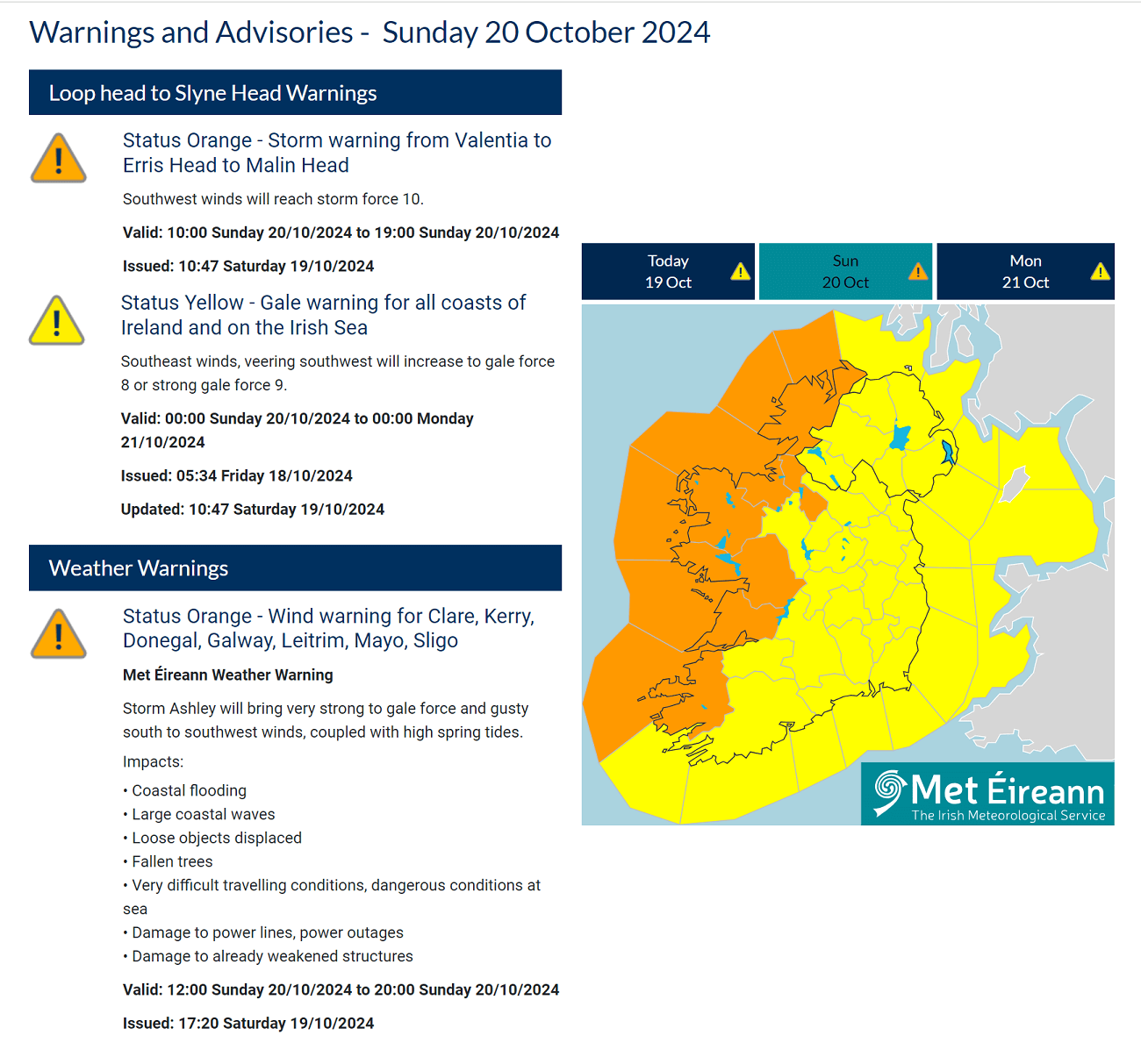

Met Éireann Weather Warning
Storm Ashley will bring very strong to gale force and gusty south-to-southwest winds, coupled with high spring tides.
Impacts:
Coastal flooding
Large coastal waves
Loose objects displaced
Fallen trees
Very difficult traveling conditions, dangerous conditions at sea
Damage to power lines, power outages
Damage to already weakened structures
Valid: 12:00 Sunday 20/10/2024 to 20:00 Sunday 20/10/2024
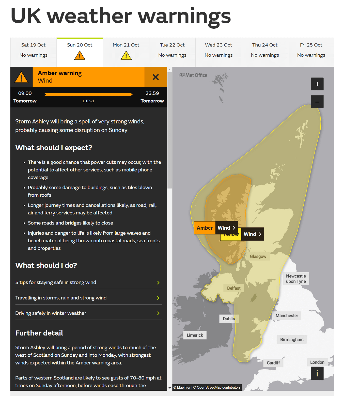
* * * * *Here are the warning messages from the Met Office, the UK governmental meteorological agency, for Sunday, October 20th, across Northern Ireland, Scotland, and northern England.

Regions and local authorities affectedHighlands & Eilean Siar
Na h-Eileanan Siar
Highland
Strathclyde
Storm Ashley will bring a spell of very strong winds, probably causing some disruption on Sunday.
What to expect?
There is a good chance that power cuts may occur, with the potential to affect other services, such as mobile phone coverage
Probably some damage to buildings, such as tiles blown from roofs
Longer journey times and cancellations are likely, as road, rail, air, and ferry services may be affected
Some roads and bridges are likely to close
Injuries and danger to life are likely from large waves and beach material being thrown onto coastal roads, sea fronts, and properties
Further detail
Storm Ashley will bring strong winds to much of the west of Scotland on Sunday and into Monday, with the strongest winds expected within the Amber warning area.
Parts of western Scotland are likely to see gusts of 70-80 mph at times on Sunday afternoon before winds ease through the evening and overnight. The winds coincide with high spring tides and large waves, which may lead to a greater risk of coastal travel disruption.
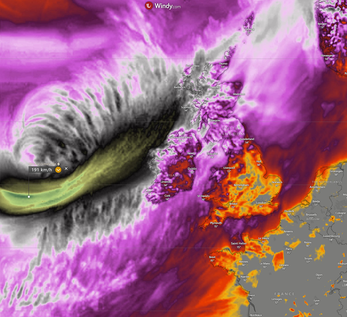
Latest high-resolution rain and wind forecast for Ashley
Update: Oct 19th, 17:30 UTC
Here is the latest update from the high-resolution weather model ICON-EU. Heavy rainfall and severe winds along Ashley’s track are forecast until Monday morning. Intense wind gusts are forecast, surpassing 150 km/h to the west of Ireland and Scotland.
The central pressure will bottom out early Sunday night, with the main front moving from southwest to northeast into Ireland and North Ireland tonight, reaching western Scotland and Outer Hebrides by Sunday morning. The front is associated with severe winds and high waves along the coastal areas. Flooding is likely due to a nearly full Moon and high tide.
Due to the explosive bombogenesis process inside the storm Ashley, a sting jet wind maximum phenomenon could develop tonight. This could push peak wind gusts into 180-200 km/h (120+ mph) in a narrow corridor south of the core.
Weather models, however, predict that most violent winds should affect the open seas west of Ireland and Scotland.
An explosive development of storm Ashley begins
Update: Oct 19th, 11:00 UTC
A water vapor satellite across the North Atlantic and Europe reveals an impressive yet rapidly developing storm, Ashley, about halfway between Newfoundland and Ireland.
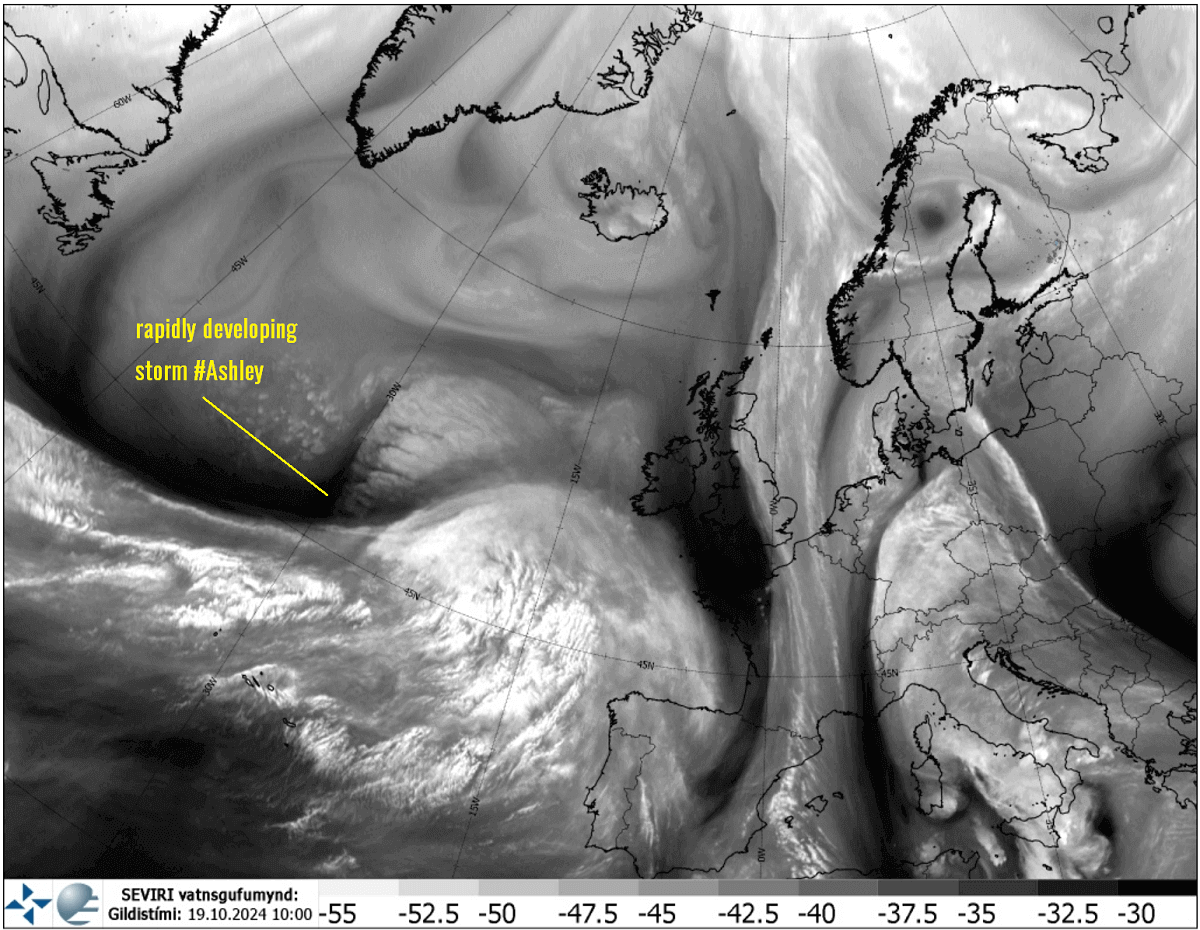

Notice a dark stripe emerging from that west, a conveyor belt penetrating around the rapidly deepening frontal system. This is the typical appearance of explosive cyclogenesis in mid-latitude storms. We will post further satellite images and animation later today as things evolve. Expect an impressive satellite presentation tonight.
Bombogenesis expected to take place, a pressure drop of 37 mbar in 24 hours
Update: Oct 19th, 7:00 UTC
The NCEP – Ocean Prediction Center (OPC) also expects Ashley to rapidly intensify this Saturday, followed by developing hurricane-force winds as the storm tracks towards the northeast.
The central pressure is expected to drop from 988 mbar observed at 6:00 UTC this morning to 951 mbar at 6:00 UTC on Sunday morning. That is a 37 mbar pressure drop in a 24-hour period, significantly surpassing the criteria for bombogenesis. When the pressure falls more than 24 mbar within one day, a storm is known as a bomb cyclone and undergoes rapid intensification.
Powerful jet stream with sustained winds above 300 km/h
Update: Oct 18th, 21:00 UTC
On Saturday, storm Ashley will begin organizing in central North Atlantic, placed underneath an impressive, powerful jet stream wind maximum aloft. The upper-level winds will increase further as the storm moves closer to Ireland and Scotland on Sunday.
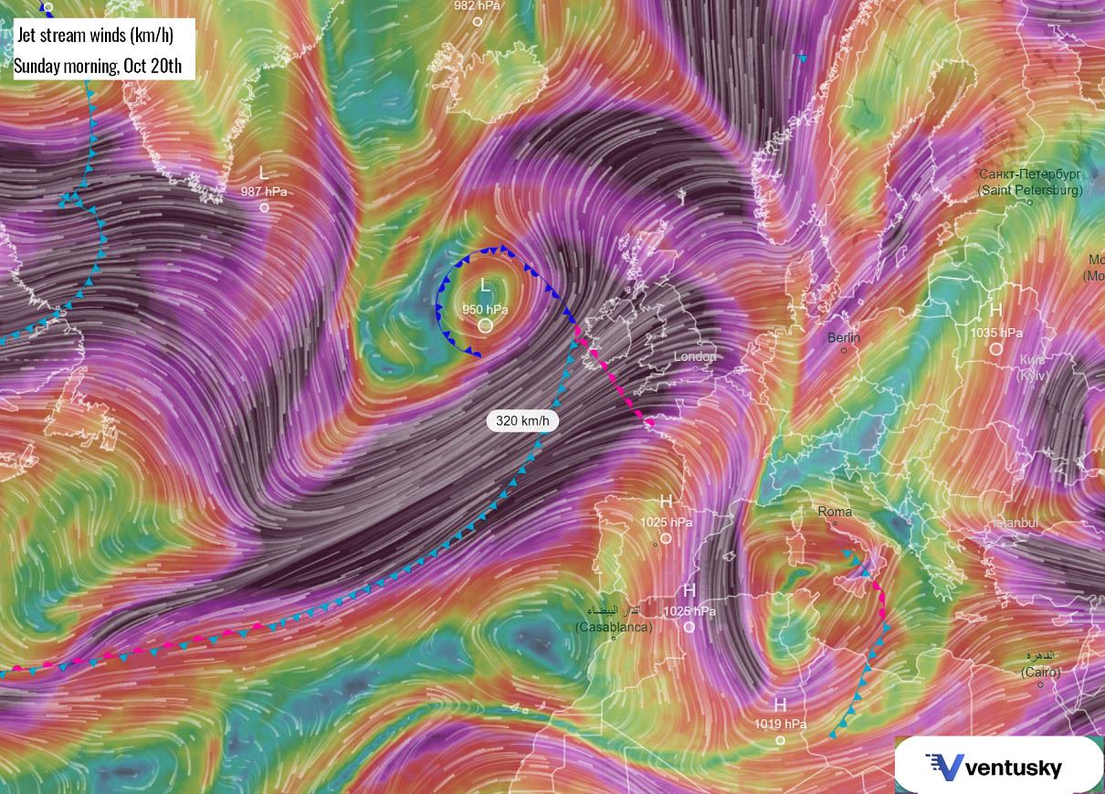

This happens because of a strong pressure and temperature gradient between the high-pressure system (blocking High) over continental Europe and a deep upper trough and rapid surface cyclogenesis forming over the Atlantic. The pressure difference will create these violent winds aloft, which are forecast to exceed 300 km/h or 185 mph.
Eastbound flights from the U.S. to Europe will take advantage of these high-speed winds, and flight times between the continents will be shorter. On the other hand, those flying westbound will travel longer than usual.
Regardless of the direction of flights, expect turbulence to likely occur while crossing the wind maximum over the weekend.
Peak wind gusts forecast by ICON-EU model
Update: Oct 18th, 12:00 UTC
The high-resolution weather models forecast that an intense windstorm will develop with storm Ashley as it nears Ireland and Scotland on Sunday.
Near its core, peak wind gusts could reach above 180 km/h (110 mph), potentially developing a sting jet phenomenon.

Read more about sting jet: What is a Sting Jet, and why is it important to understand its dangerous impacts?
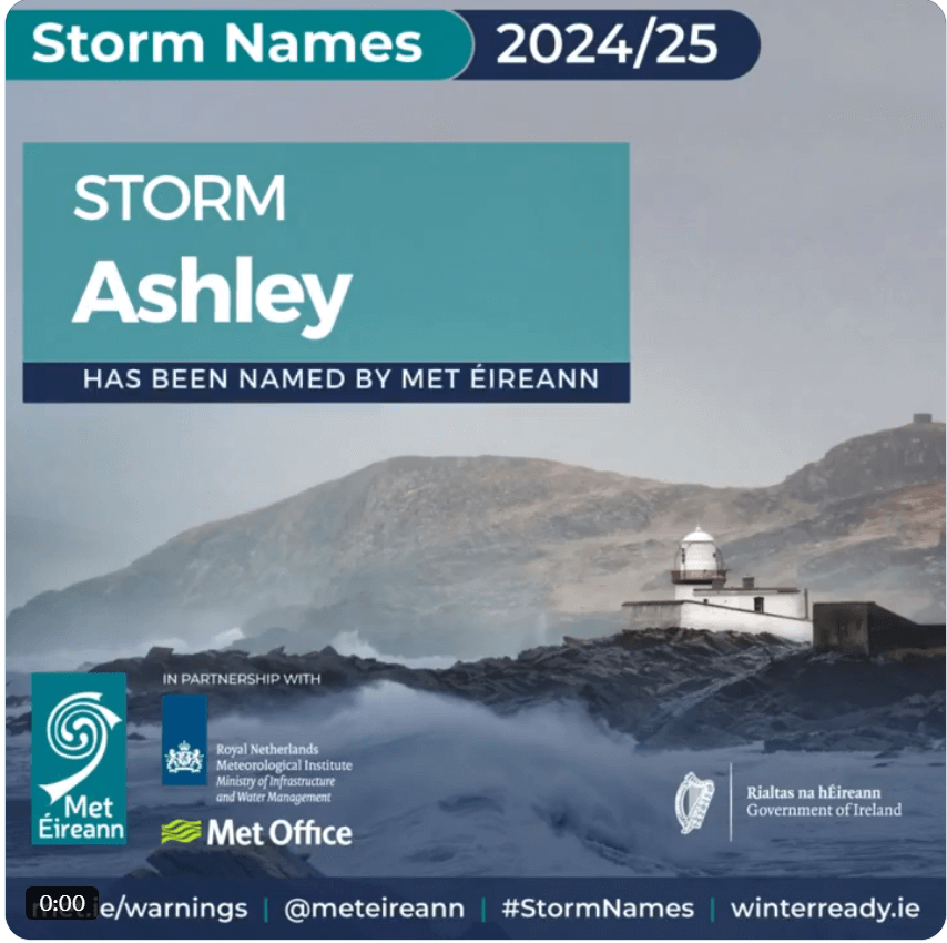
The Irish Meteorological Service has named Storm Ashley
Update: Oct 18th, 8:00 UTC
The Irish Meteorological Service (Met Éireann) named the storm Ashley on Friday, October 18th, 2024. This is the first named North Atlantic storm of the ongoing season.
Here is the official statement from Met Éireann: Met Éireann announcement on X

Storm Ashley will bring strong and gusty southerly winds and high spring tides to Ireland, Northern Ireland, and Scotland on Sunday and Monday.
Our official forecast of the Storm Ashley can be found below:
An explosive development of storm Ashley will blast into Ireland and Scotland on Sunday
Source link : https://www.severe-weather.eu/global-weather/live-tracking-storm-ashley-impact-ireland-and-scotland-mk/
Author :
Publish date : 2024-10-18 16:15:00
Copyright for syndicated content belongs to the linked Source.