One of Iceland’s largest volcanoes is on the brink of erupting, experts have warned.
Bárðarbunga – the second-largest volcano in the country – has been hit with a swarm of 130 earthquakes within just five hours.
This is a key sign an eruption could be imminent, according to The Icelandic Meteorological Office (IMO).
As a precaution, the aviation colour-code for Bárðarbunga has been raised from green to yellow, indicating ‘heightened activity above normal background levels’.
Aviation colour-codes give pilots and aviation authorities information about the potential presence of volcanic ash in the atmosphere, which could impair flights.
Bárðarbunga – located under Iceland’s largest ice cap (Vatnajökull) in the centre of the country – last erupted a decade ago, prompting a red travel alert.
The volcano’s previous eruption in 2014/15 emitted large volumes of sulphur dioxide and impacted air quality.
However, there was little effect on flights outside of the immediate vicinity as it didn’t produce as much volcanic ash.
Your browser does not support iframes.
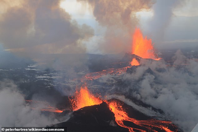
The 2014-2015 Holuhraun eruption was the largest outbreak in Iceland for over 300 years and lasted for almost six months. Pictured, September 4, 2014
‘Bárðarbunga is unique in that it is an unusually large volcanic system, partly covered by a glacier,’ said the IMO in a statement.
‘The observed seismicity is consistent with increased pressure caused by magma accumulation, which has been ongoing since the last eruption in 2015.’
Fears started on Tuesday when a ‘strong’ earthquake swarm began shortly after 6am UTC in the northwestern part of the Bárðarbunga caldera, according to IMO.
Earthquake activity was most intense until around 9am UTC, after which it began to decrease, although earthquakes are still being recorded in the area, it said.
The largest quake at 8:05 UTC registered at magnitude 5.1, capable of ‘minor damage’, while 17 earthquakes measured magnitude 3 or higher.
Earthquake activity has been increasing gradually in Bárðarbunga over recent months and four earthquakes measuring magnitude 5 or higher were detected in 2024, the department added.
In the past four years, the Icelandic volcanoes of Fagradalsfjall and Sundhnúkur have hit the headlines for consistent eruptions, although these are further southwest, closer to capital city Reykjavík.
Many of these eruptions were preceded by earthquakes with magnitudes somewhere between five and six.
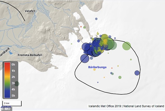
This map from the Icelandic Meteorological Office’s earthquake monitoring system shows the locations of the earthquakes, with the black circle indicating the Bárðarbunga caldera outline. Bárðarbunga is located under Iceland’s most extensive glacier (Vatnajökull) in the centre of the country. It is 2,300 feet deep with a total area of 25 square miles
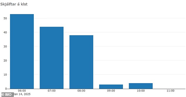
This bar chart indicates the hourly earthquake count. Earthquake activity was most intense until around 9:00 UTC, after which it began to decrease, though earthquakes are still being recorded in the area. It is too early to determine whether the swarm is subsiding
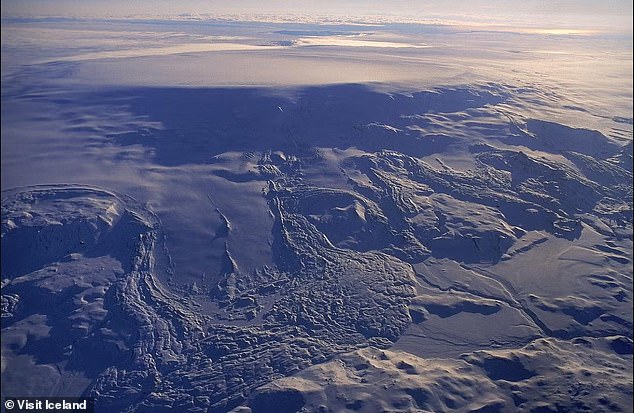
Bárðarbunga is located under Iceland’s largest ice cap (Vatnajökull) in the centre of the country. Bárðarbunga’s ice-filled crater or ‘caldera’ is 6.2 miles wide
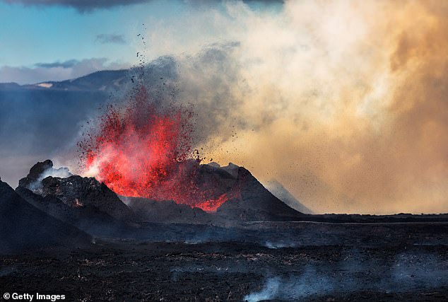
On August 29, 2014, a fissure eruption started in Holuhraun at the northern end of a magma intrusion that had moved progressively north, from the Bardarbunga volcano. Bardarbunga is a stratovolcano located under Vatnajokull, Iceland’s most extensive glacier
Why does Iceland get so many earthquakes and volcanic eruptions?
Iceland is a particular hotspot for seismic activity because it sits on a tectonic plate boundary called the Mid Atlantic Ridge.
The Mid Atlantic Ridge is a long chain of mountains that stretches down the Atlantic ocean, meaning most of these mountains are underground.
It’s gradually pushing North America and Eurasia away from each other.
There are only a few places on Earth where the Mid Atlantic Ridge is exposed on land, but Iceland – which is slap bang in the middle of the ridge – is one of them.
But Iceland is also located over a mantle plume – a column of hot, molten rock that rises from the deep mantle to the surface, becoming lava when it erupts.
However, unlike recent eruptions in the Reykjanes Peninsula, Bárðarbunga is located in a more remote area, within Iceland’s largest ice cap, meaning people and infrastructure are less at risk.
Earthquakes can trigger volcanic eruptions through severe movement of tectonic plates – the jigsaw-style sections of Earth’s crust and uppermost mantle.
Valentin Troll, professor of petrology and geochemistry at Uppsala University in Sweden, thinks the swarms could potentially lead to an eruption.
‘The unrest at Bárðarbunga is in addition to long term inflation of the system over the last few years and could herald developments towards a new eruption,’ he told MailOnline.
‘However, earthquake swarms like the recent one are not necessarily leading to an eruption, and it is thus too early to be certain.
‘If an eruption occurs, it would possibly look like a repeat of the 2024/15 eruption, which was spectacular to watch but posed no serious danger to populations or livestock and infrastructure due its relative remoteness.
‘Alternatively, we may face an eruption inside the caldera (under the ice), which could lead to unpleasant phreatomagmatic eruptions where magma/lava and glacial melt water interact to cause steam explosions.’
Dr Philip Collins, deputy dean at Brunel University London’s department of civil and environmental engineering, said the new earthquakes ‘reflect the movement of magma at depth’.
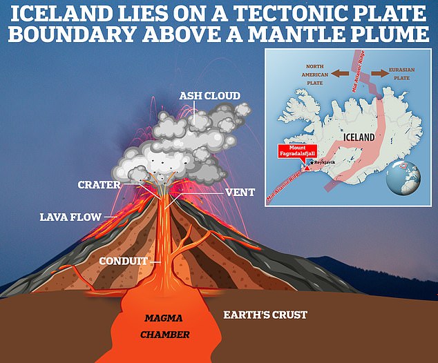
Iceland is a particular hotspot for seismic activity because it sits on a tectonic plate boundary called the Mid Atlantic Ridge
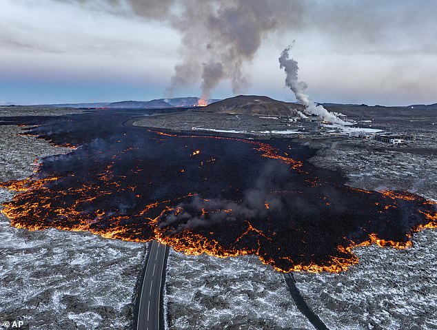
Lava pictured flowing across one of the roads near Grindavik on November 21, 2024 with the Blue Lagoon geothermal spa to the right
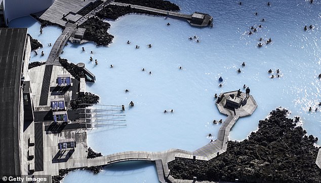
Pictured, Iceland’s popular Blue Lagoon geothermal spa, a popular tourist attraction, which has repeatedly been closed and reopnened in the last few years
‘At the moment, there’s no indication that big eruption will happen, but volcanoes can be difficult to predict,’ Dr Collins told MailOnline.
‘[The magma] may be forcing its way into new areas and causing fracturing of the rock at depth, but whether there is enough volume or pressure for this to reach the surface isn’t clear yet.
‘If an eruption did occur, the first sign might be increased meltwater from the glacier that sits over much of the volcanic area.’
Large earthquakes – greater than magnitude 6 – can trigger an eruption or to some type of unrest at a nearby volcano, according to the United States Geological Survey (USGS).
Volcanoes can only be triggered into eruption by nearby tectonic earthquakes if they are already poised to erupt – when there’s enough ‘eruptible’ magma within the volcanic system and significant pressure within the magma storage region.
‘If those conditions exist, it’s possible that large tectonic earthquakes might cause dissolved gases to come out of the magma (like a shaken soda bottle), increasing the pressure and possibly leading to an eruption,’ USGS says.
In the past four years, Iceland has seen a series of eruptions at the Reykjanes Peninsula, a volcanic hotspot southwest of capital Reykjavik.
After remaining dormant for 800 years, the Reykjanes Peninsula suddenly became active again in 2021 at the Fagradalsfjall volcano.
In late 2023 and early 2024, new volcanic fissures formed near the fishing town of Grindavik, pumping huge plumes of lava out onto the surface.
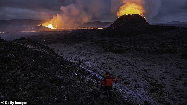
The most recent eruptions in 2024 (pictured) led to the evacuation of the fishing town of Grindavik and the Blue Lagoon resort
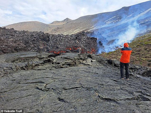
However, scientists now say that the eruptions that have rocked the island could continue for decades
The resulting eruptions led to the evacuation of the town, destroyed houses and repeatedly closed the Blue Lagoon – one of the country’s most popular tourist destinations.
In November 2024, the geothermal spa closed when its car park was engulfed in lava, although the Blue Lagoon website says ‘specialized protective barriers’ are ‘safeguarding Blue Lagoon’s vital infrastructure against potential lava flows’.
For many locals, the events have revived the trauma of the disastrous explosion at another of Iceland’s volcanoes, Eyjafjallajokull, back in 2010.
While the eruption didn’t kill anyone, it did produce a huge cloud of ash that prompted the biggest global aviation shutdown since World War II.
How a volcanic eruption in 2010 sparked almost a month of chaos for European air travel
A volcanic eruption in Iceland in 2010 sparked the worst air travel disruption since the Second World War.
Chaos descended within the European travel industry when an unfortunate series of phenomenons combined from a number of relatively small volcanic events at Eyjafjallajokull, on the south side of the island.
Seismic activity had started at the end of 2009 and had intensified up until March 20, when the volcano – which is covered by an ice cap – finally erupted.
The eruption was small – just one out of seven on the scale used to measure eruptions. Globally, it appeared a relatively small event at the time.
But around five days later, scientists began to notice unusual activity.
They found evidence at magma was flowing from underneath the crust into Eyjafjallajokull’s magma chamber and that pressure stemming from the process caused a huge crustal displacement.
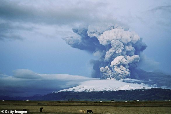
While the eruption began as an effusive eruption – where lava runs from the volcano along the ground – the volcano then entered an explosive stage on April 14. This time, the explosion was measured as a four on the volcanic scale
Meanwhile, ice surrounding the volcano started melting and began flooding into the volcano.
This rapid cooling caused the magma to shear into fine and jagged ash particles. It also increased the volcano’s explosive power.
While the eruption began as an effusive eruption – where lava runs from the volcano along the ground – the volcano then entered an explosive stage on April 14. This time, the explosion was measured as a four on the volcanic scale.
A huge ash cloud was fired into the air, reaching up to nine kilometres in height. Around 250 million cubic metres of volcanic material was also spewed into the air as a result of the explosion.
To make matters worse, the volcano was directly under a jet stream and the rapid cooling from the ice water gave the volcano enough power to shoot the ash directly into it.
The jet stream was also unusually stable at the time and sent ash particles from the volcano continuously southeast – towards Europe.
From April 14-20, ash from the volcanic eruption covered large areas of Northern Europe.
About 20 countries closed their airspace to commercial jet traffic and it affected approximately 10 million travellers, with nearly 100,000 flights to and from and within Europe cancelled across the six day period.
The Airport Operators Association (AOA) estimated that airports lost £80 million over the six-and-a-half days, while the knock-on disruption lasted for around a month.
In the United Kingdom alone thirteen travel firms collapsed during the summer of 2010. The ash cloud disruption was cited as one of the contributing factors.
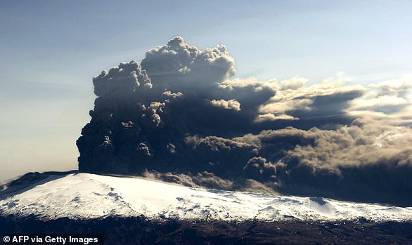
A huge ash cloud was fired into the air, reaching up to nine kilometres in height. Around 250 million cubic metres of volcanic material was also spewed into the air as a result of the explosion
Several sports matches were postponed, while Liverpool football club had to travel by coach to Madrid in order to play a match in the Europa League.
While the travel disruption mostly ran throughout April, volcanic activity continued at Eyjafjallajokull until October, when scientists declared the eruption was over.
In 2011, a volcano under the Vatnajökull glacier sent thousands of tonnes of ash into the sky in a few days, raising concerns of a repeat of the travel chaos seen across northern Europe.
Though the explosion was larger than Eyjafjallajokull, the impact was not as wide-spread.
A total of 900 flights (out of 90,000 in Europe) were cancelled as a result of the eruption in the period May 23-25.
In 2014, Bárðarbunga erupted in what was the biggest eruption in Iceland in more than 200 years. However, only local travel was impacted as a result.
Source link : http://www.bing.com/news/apiclick.aspx?ref=FexRss&aid=&tid=6789861bc6364cc2a02ab5c0b931ee24&url=https%3A%2F%2Fwww.dailymail.co.uk%2Fsciencetech%2Farticle-14291725%2Ficeland-volcano-preparing-erupt-travel-chaos-europe.html%3Fci%3Dtffm-u2_-8%26cri%3Dih_ktDI8Gs%26si%3D0eH3baIz7d2N%26xi%3D55707c7a-3c92-4826-98db-a0966e5ff85f%26ai%3D14291725&c=11590848536600075302&mkt=de-de
Author :
Publish date : 2025-01-16 06:40:00
Copyright for syndicated content belongs to the linked Source.


